
In the current context, technology presents itself as an indispensable tool in several areas, including surveying and urban planning. With the advancement of smartphones and applications, it has become possible to carry out land measurements in a faster, more efficient and accessible way. These digital solutions offer a practical alternative to traditional methods, enabling professionals and amateurs alike to obtain accurate estimates without the need for specialized equipment.
Land measurement applications use various technologies, such as GPS, augmented reality and digital maps, to provide data on areas, perimeters and other relevant characteristics. These tools have become popular not only with engineers, architects and surveyors, but also with farmers, builders and individuals interested in space planning or buying and selling property. They offer an intuitive and interactive way to view and manage land information, facilitating decisions based on accurate data.
Main Applications on the Market
Exploring the main applications on the market is essential to understand how technology has facilitated the task of measuring land. Each app offers a unique set of features, making it suitable for different needs and preferences.
Google Earth
Google Earth is a powerful tool that allows users to view the world from a satellite perspective, including measuring areas and distances with relative ease. Through a user-friendly interface, users can navigate through different regions, obtain precise coordinates and estimate the size of specific plots of land. Furthermore, the application offers features such as 3D visualization of land and buildings, which makes it easier to understand space in different contexts.
The potential of Google Earth goes beyond basic measurements, providing a platform rich in geographic information that can be used for urban planning, environmental studies and construction projects. The ability to integrate personalized data and use layers of information makes this application a versatile tool for professionals in the field.
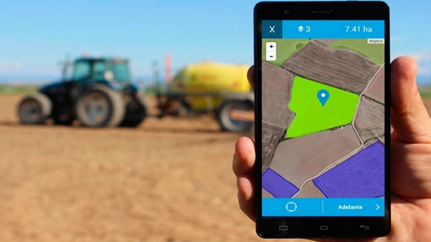
Land Calculator
Land Calculator is an application specialized in measuring land areas and perimeters. With a simple and intuitive interface, it allows users to map terrain manually or using GPS coordinates. This tool is particularly useful for farmers and builders who need quick and accurate estimates for planning and project management.
In addition to its basic functionalities, Land Calculator offers advanced features such as the ability to save measurements, share results and view detailed information about the measured terrain. These features make the app a popular choice among professionals looking for efficiency and accuracy in their measurements.
Planimeter
Planimeter is an application aimed at measuring distances and areas in any way, using both GPS and manual point entry. This application stands out for its accuracy and ease of use, being a valuable tool for professionals involved in construction, landscaping and territorial planning projects.
The application allows users to calculate areas, perimeters and distances between points, offering a variety of measurement units to meet the specific needs of each project. Furthermore, Planimeter enables data export and integration with other applications and services, expanding its usefulness in the professional field.
GPS Fields Area Measure
GPS Fields Area Measure is a popular option among those who need accurate measurements of large areas of land. Using GPS to capture points, this application is capable of providing area and perimeter estimates with high accuracy. It is especially useful for farmers, engineers, and urban planning professionals who need detailed information about vast tracts of land.
In addition to its measurement functionalities, the application offers features such as saving and sharing measurements, which facilitate collaboration between teams and project management. Its user-friendly interface and the possibility of working in different measurement units make GPS Fields Area Measure an indispensable tool for many professionals.
MapPad
MapPad is another robust tool designed to make measuring and mapping terrain easier. With features that allow you to measure distances, areas and perimeters using GPS or manual mapping, MapPad is ideal for professionals working in urban planning, property management and construction. This application stands out for its ability to generate detailed reports, including area statistics and location data, which can be easily shared or exported for use in other software.
The functionality of adding notes and marking points of interest on the map makes MapPad particularly useful for projects that require detailed terrain analysis. Its intuitive interface and flexibility to work with multiple layers of data ensure that MapPad is a reliable choice for professionals in the field.
Advanced Features and Usage Tips
When considering using applications for land measurement, it is important to explore advanced features that can optimize work and offer more accurate results. Many of these applications allow integration with other software and services, facilitating data management and sharing information between teams. Additionally, features such as viewing in different modes (satellite, terrain, 3D) and the ability to add annotations or mark points of interest can enrich project analysis and planning.
FAQ
Q: Are land measurement apps accurate? A: Yes, many applications offer very high accuracy, especially those that use GPS. However, accuracy may vary depending on site conditions, GPS signal quality, and the specific technology used by the application.
Q: Can I use these apps for official measurements? A: While many applications are accurate and useful for a variety of purposes, official measurements typically require validation from a licensed professional and the use of specialized measurement equipment.
Q: Is it possible to export measurement data? A: Yes, most applications allow you to export data in different formats, facilitating integration with other planning or GIS software.
Conclusion
Applications for measuring terrain represent a revolution in the way we interact and manage information about space. They offer a combination of precision, efficiency and affordability that was unthinkable just a few decades ago. Whether for professional or personal use, these digital tools open up new possibilities for land planning and management, democratizing access to precise geographic information and facilitating data-based decision making. As technology continues to evolve, we can expect improvements and new features that will make these applications even more indispensable in the future.